 


Weather data
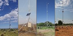
A large number of automatic weather stations has been implemented in the frame of the BIOTA AFRICA project by the Namibian National Botanical Research Institute (NBRI) and the Group "Biodiversity, Evolution and Ecology" (BEE) of the University of Hamburg. The website offers hourly updates of data and graphs of a large number of weather parameters.

|
 Kenya Kenya
< Geodata Service < Geodata Catalogue
For download a password is required
| Orography and Landscape |
| |
meta information
 |
quicklook
 |
download
 |
| Elevation Contour Lines |
 |
 |
 |
| Elevation Zones |
|
|
|
| Elevation Points |
|
|
|
| Digital Elevation Model (ILRI) |
|
|
|
| Digital Elevation Model (GTOPO30) |
|
|
|
| Landscapes |
|
|
|
| Hydrography |
| |
meta information
|
quicklook
|
download
|
| Rivers |
|
|
|
| Rivers, Canals, etc. |
|
|
|
| Wetlands |
|
|
|
| Water Points |
|
|
|
| Geology and Soil |
| |
meta information
|
quicklook
|
download
|
| Geology |
|
|
|
| Soils |
|
|
|
| Climate |
| |
meta information
|
quicklook
|
download
|
| Agro-Climatic Zones |
|
|
|
| Agro-Ecological Zones |
|
|
|
| Annual Rainfall |
|
|
|
| Rainfall Stations (ILRI) |
|
|
|
| Rainfall Stations (WMO) |
|
|
|
| Forest |
| |
meta information
|
quicklook
|
download
|
| Forests |
|
|
|
| Major Forest Ranges |
|
|
|
| Percentage Tree Cover |
|
|
|
| Land Use/Cover |
| |
meta information
|
quicklook
|
download
|
| Land Use/Cover (GLC 2000) |
|
|
|
| Land Use/Cover (JICA) |
|
|
|
| Land Cover (MODIS 2004) |
|
|
|
| Land Cover (MODIS 2000) |
|
|
|
| Land Use/Cover of Forest Areas (KIFCON) |
|
|
|
| Vegetation/Land Cover |
|
|
|
| Aerial and Satellite Imagery |
| |
meta information
|
quicklook
|
download
|
| Landsat Mosaic |
|
|
|
| Boundaries |
| |
meta information
|
quicklook
|
download
|
| State Boundary |
|
|
|
| Province Boundaries |
|
|
|
| District Boundaries |
|
|
|
| Division Boundaries |
|
|
|
| Location Boundaries |
|
|
|
| Sublocation Boundaries |
|
|
|
| Gazetted Protected Areas |
|
|
|
| Infrastructure |
| |
meta information
|
quicklook
|
download
|
| Roads |
|
|
|
| Railways |
|
|
|
| Towns and Urban Centres |
|
|
|
| Population |
| |
meta information
|
quicklook
|
download
|
| Population in 1989 |
|
|
|
| Population in 1979 |
|
|
|
| Poverty in 1999 |
|
|
|

|
|
 Go to the WeatherNet