 


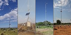
Weather data
A large number of automatic weather stations has been implemented in the frame of the BIOTA AFRICA project by the Namibian National Botanical Research Institute (NBRI) and the Group "Biodiversity, Evolution and Ecology" (BEE) of the University of Hamburg. The website offers hourly updates of data and graphs of a large number of weather parameters.

|
Metadata database
Metadata introduction
Land cover and Land cover change for the GLOWA Volta Basin
 Download PDF document Download PDF document
 Last update: 2009-12-02 Done by: Tobias Landmann / Gerhard Muche
 Copy dataset as template Copy dataset as template
| Dataset metadata |
| Description | Land cover thematic classification result at 250-meter resolution using the FAO Land Cover Classification System (LCCS) standard; LC change estimates from LCCS from 1990/1 to 2000/1 |
| Purpose |
LCCS described to improve biodiversity estimates, Vegetation changes related to LCCS themes, including magnitudes of change to improve biodiversity and hydrological budget estimates |
| Main theme(s) |
Climate change, deforestation, LC change factors, LC change rates, LCCS static LC |
| Subtheme(s) |
Carbon stock estimates, Changes in species habitats & hydrological regimes |
| Biome(s) |
Guinean savanna mosaic, tropical rainforest, shrubland savanna, semi-arid grasslands |
| Country(ies) |
Ghana, Burkina Faso, Benin (partially), Cote Ivoire (partially), Mali (partially), Togo (partially). |
| Administration unit(s) |
Including districts in Ghana and Burkina Faso |
| Locality(ies) |
|
| BIOTA Observatory(ies) |
BIOTA West LCCS field data derived from the whole BIOTA West study area (used for validation) |
| Period(s) |
1990/1, 2000/1 |
| Sampling method(s) |
LCCS field sampling protocol on general and specific land cover. Land Cover classes from 1 to 10 |
| Responsible person(s) |
Tobias Landmann |
| Regional networks(s) |
BIOTA West Africa |
| Related subprojects / workpackages / topics |
CT1, topic 1 and 2, CT2, topic 1 |
| Copyright holder |
University of Wuerzburg, German Aerospace Centre (DLR) |
| Restrictions of dissemination |
(4) Data provider |
| Start time of protection |
n/a |
| Duration of protection |
n/a |
| Rationale / notes |
ongoing analysis for publication of results on LC synthesis in BIOTA West |
| Data |
| Format |
Raster, ERDAS Imagine files (*.img) |
| File name(s) / size(s) |
Landsat TM/ETM+ path row |
| Software requirements |
Remote Sensing or GIS software |
| Documentation |
|
| Format |
Microsoft PowerPoint |
| File name(s) |
LUCCGLOWA_finalmaps90_2000_quicklooks.ppt |
| Status |
available |
| Notes |
data is also part of the GLOWA Volta project |
| Related publications |
Landmann, T., Schmidt, M., Dech, S., Schramm, M., Vogel, M. (2006): A new spatially-explicit and object-conditional land cover (LC) data set based on the FAO Land Cover Classification System (LCCS) for the GLOWA catchment area, Proceeding of the 6th AARSE international conference on earth observation and geoinformation sciences in support of Africa's development, 30 October - 2 November 2006, Cairo, Egypt. Cairo: The National Authority for Remote Sensing and Space Science (NARSS), 2006. ISBN 1-920-01710-0. pp144-149 |
| Contact person |
Landmann, Dr. Tobias
University of Würzburg, DLR Remote Sensing Unit
Mineralogical Institute, Fernerkundung, Am Hubland
97074 Wuerzburg
Germany
Phone: +49 931 31 81869
Fax: +49 931 888 4961
 tobias.landmann@mail.uni-wuerzburg.de tobias.landmann@mail.uni-wuerzburg.de
Position: Senior Researcher, Sub-project leader; Remote Sensing
Website
|
|
|
 Go to the WeatherNet