 


Weather data
A large number of automatic weather stations has been implemented in the frame of the BIOTA AFRICA project by the Namibian National Botanical Research Institute (NBRI) and the Group "Biodiversity, Evolution and Ecology" (BEE) of the University of Hamburg. The website offers hourly updates of data and graphs of a large number of weather parameters.
|
< back
Subproject S01
Dr. Gerald Braun, DLR, Deutsches Zentrum fuer Luft- und Raumfahrt e.V., Deutsches Fernerkundungsdatenzentrum, Linder Hoehe, 51147 Köln
Remote sensing and GIS based survey of spatial and temporal biodiversity dynamics and analysis of biodiversity and geodiversity interrelationships
|
This project shall create the basis for a system in which both, remote sensing and GIS applications, form an analysis and monitoring system for the assessment of human impacts on biological diversity. It is our aim to make the existent biodiversity more understandable and predictable, taking into account the UN-Convention on Biological Diversity (UNCBD).
It is planned to establish a coherent GIS along the entire BIOTA transect in order to allow the analysis of spatial patterns of biodiversity, its temporal changes and the mutual depency of geodiversity and biological diversity. Focus will lie on the comparison of natural ecosystems with those where socio-economic activity has led to various degradation levels of the former natural ecosystems. Furthermore, with respect to the possible detection of indications of spatial patterns of diversity by remote sensing techniques it is aimed to contribute to future monitoring and conservation concepts.
The major workpackages comprise
- the vegetation mapping along the transect band on basis of remote sensing techniques (in close co-operation with the S06 project)
- the building and continuous extension of a GIS as platform for the mapping of the vegetation, analysis of historic satellite data with respect to land use/degradation, integration of important abiotic parameters (e.g. climate, soil, land use) and punctual data of the project partners on diversity
- capacity building in GIS and remote sensing techniques is planned for the co-operation partners including a know-how transfer towards the involved institutions
- analysis of the dependency of geodiversity and biological diversity with respect to spatial and temporal dynamics as well as the socio-economic impact. Here, it is also aimed to produce a draft diversity map and to make a phytosociological interpretation of vegetation- and diversity patterns feasible.
|
|
|
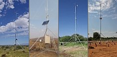
 Go to the WeatherNet