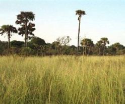
The Ivorian Station d´Ecologie Tropicale de LAMTO is a field station with a long tradition. Research in several ecological disciplines has been carried out there since 1964 mainly by French research programmes (CNRS) which provides long term data for the site. BIOTA West started its work in 2003, four observatories have been established inside and outside the reserve. For reasons of standardisation and comparison, all four observatories include the ecosystems characteristic for the forest-savanna mosaic of the central Guinean zone: grass, shrub, and tree savanna, savanna woodland, semi-deciduous forest islands, gallery forests, and temporal pools, or the substituting anthropogenic communities. The subprojects working on remote sensing, botany, frogs and termites are co-operating here on the impact of anthropogenic disturbances on biodiversity, with special emphasis on changes of plant diversity and alterations of population dynamics of insects, especially of termites as ecosystem engineers and on the impact of fire on the structure and dynamic of biodiversity in savannas |