 


Weather data
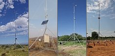
A large number of automatic weather stations has been implemented in the frame of the BIOTA AFRICA project by the Namibian National Botanical Research Institute (NBRI) and the Group "Biodiversity, Evolution and Ecology" (BEE) of the University of Hamburg. The website offers hourly updates of data and graphs of a large number of weather parameters.

|
 Uganda Uganda
< Geodata Service < Geodata Catalogue
For download a password is required
| Orography |
| |
meta information
 |
quicklook
 |
download
 |
| Elevation Contour Lines |
 |
 |
 |
| Elevation Zones |
|
|
|
| Elevation Points |
|
|
|
| Digital Elevation Model (GTOPO30) |
|
|
|
| Hydrography |
| |
meta information
|
quicklook
|
download
|
| Rivers, Canals, etc. |
|
|
|
| Climate |
| |
meta information
|
quicklook
|
download
|
| Daily Rain and Temperature Data (12 Stations, 1977-97) |
|
|
|
| Land Use/Cover |
| |
meta information
|
quicklook
|
download
|
| Land Use/Cover (GLC 2000) |
|
|
|
| Land Cover (MODIS) |
|
|
|
| Boundaries |
| |
meta information
|
quicklook
|
download
|
| State Boundary |
|
|
|
| Infrastructure |
| |
meta information
|
quicklook
|
download
|
| Roads |
|
|
|
| Railways |
|
|
|
| Towns and Urban Centres |
|
|
|

|
|
 Go to the WeatherNet