

Weather data
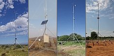
A large number of automatic weather stations has been implemented in the frame of the BIOTA AFRICA project by the Namibian National Botanical Research Institute (NBRI) and the Group "Biodiversity, Evolution and Ecology" (BEE) of the University of Hamburg. The website offers hourly updates of data and graphs of a large number of weather parameters.

|
 BIOTA East Africa - Workpackage(s)
Subproject |
E02 - GIS and Remote Sensing in Support of Biodiversity Management at the Landscape Scale for Rainforests in Eastern Africa |
Workpackage |
WP2: Spatial extrapolation of BIOTA-East findings on biodiversity and ecosystem function predominantly over Kakamega Forest, plus interdisciplinary analyses considering spatial information |
Project leader(s) |
Prof. Dr. Gertrud Schaab,
Tobias Lung |
Project description |
- Updating land use/cover change (LUCC) time series based on Landsat (or comparable satellite imagery) for the 3 forest areas studied
- Applying landscape metrics for gaining biodiversity-relevant indices, also for all 3 forest areas
- Development of GIS-based models for simulating forest biodiversity change
- Spatial extrapolation of data on biodiversity and ecosystem function as derived in the field over the complete Kakamega Forest and its fragments (in close cooperation with E11)
- Further interdisciplinary cooperations with other BIOTA-East subprojects concerning those working-group specific research questions including spatial information
Workpackage 2 provides the basis for a spatial extrapolation of the diverse BIOTA-East field data on biodiversity and ecosystem function. Based on updated LUCC time series and specific derivates, i.e. biodiversity-relevant indicators, the statistical analysis results of E11 regarding correlations between biodiversity, ecosystem functioning and human impact as observed in Kakamega Forest and its fragments (see their workpackage 3) are to be extrapolated in space. In order to allow scenarios on forest biodiversity change GIS-based models are
developed. The results form an important contribution to participatory forest management.
|
Keywords |
remote sensing, forest land cover change timeseries, landscape metrics, biodiversity-relevant indices, spatial extrapolation, forest biodiversity change models, interdisciplinary cooperation |
Contribution to
cross-cutting themes (CCT) |
- Monitoring and assessment of biodiversity in space and time (Theme1)
- Understanding natural processes of change (Theme2)
- Understanding human use, value and impact in space and time (Theme3)
- Recommendations and measures for sustainable use of biodiversity (Theme4)
|
Link to Subproject |
E01
E03
E04
E10
E11
E16
|
|
|


 Go to the WeatherNet
 BIOTA East Africa - Workpackage(s)