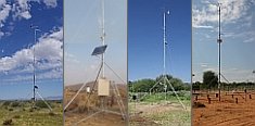 


Weather data
A large number of automatic weather stations has been implemented in the frame of the BIOTA AFRICA project by the Namibian National Botanical Research Institute (NBRI) and the Group "Biodiversity, Evolution and Ecology" (BEE) of the University of Hamburg. The website offers hourly updates of data and graphs of a large number of weather parameters.

|
Metadata database
Metadata introduction
Vegetation maps Comoé
 Download PDF document Download PDF document
 Last update: 2008-01-28 Done by: Dr. Dethardt Goetze
 Copy dataset as template Copy dataset as template
| Dataset metadata |
| Description | Principal Component Analysis of seven satellite images, multi-temporal unsupervised classification, verification by means of aerial photographs and field data, creation of GIS maps of selected single vegetation classes |
| Purpose |
Creation of generalized maps of the vegetation cover and selected ecosystems of the southern Comoé National Park and the adjacent utilized area south of the park. Differentiation of gallery forest, island forests and the principal savanna types. |
| Main theme(s) |
- Conservation
- Landscape
- Vegetation
|
| Subtheme(s) |
- Ecosystem pattern
- Forestsavanna mosaic
- Landscape diversity
- Remote sensing
- Vegetation mapping
|
| Biome(s) |
South Sudanian savanna woodland |
| Country(ies) |
Ivory coast |
| Administration unit(s) |
Préfecture Nassian |
| Locality(ies) |
Comoé National Park |
| BIOTA Observatory(ies) |
- Comoé 1
- Comoé 2
- Comoé 3
|
| Period(s) |
2000-2002 |
| Sampling method(s) |
Multi-temporal unsupervised classification of satellite images |
| Responsible person(s) |
Daniela Gurlin |
| Regional networks(s) |
BIOTA West Africa |
| Related subprojects / workpackages / topics |
CT3-WP4 Botanical collections in West Africa |
| Copyright holder |
Daniela Gurlin |
| Restrictions of dissemination |
(4) Data provider |
| Start time of protection |
January 2001 |
| Duration of protection |
10 years |
| Rationale / notes |
Ongoing utilization for further analyses and publications |
| Data |
| Format |
Erdas Imagine |
| File name(s) / size(s) |
- Vegetationskarte.img / 22.3 MB, Vegetationskarte.rrd / 2MB, Waldkarte.img / 22.3 MB, Waldkarte.rrd / 2 MB
|
| Software requirements |
Erdas Imagine, ArcView |
| Documentation |
|
| Format |
Adobe Acrobat Reader |
| File name(s) |
Diploma thesis D Gurlin.pdf, Diploma thesis D Gurlin appendix.pdf |
| Status |
completed |
| Notes |
|
| Related publications |
|
| Contact person |
Goetze, Dr. Dethardt
Dep. of Botany, University of Rostock
Wismarsche Strasse 8
18051 Rostock
Germany
Phone: +49 381 498-6206
Fax: +49 381 498-6202
 dethardt.goetze@uni-rostock.de dethardt.goetze@uni-rostock.de
Position: Project coordinator
Website
|
|
|


 Go to the WeatherNet
 Download PDF document
 Last update: 2008-01-28 Done by: Dr. Dethardt Goetze