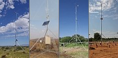 


Weather data
A large number of automatic weather stations has been implemented in the frame of the BIOTA AFRICA project by the Namibian National Botanical Research Institute (NBRI) and the Group "Biodiversity, Evolution and Ecology" (BEE) of the University of Hamburg. The website offers hourly updates of data and graphs of a large number of weather parameters.

|
Metadata database
Metadata introduction
Wetlands & wetland biodiversity
 Download PDF document Download PDF document
 Last update: 2009-12-02 Done by: Tobias Landmann / Gerhard Muche
 Copy dataset as template Copy dataset as template
| Dataset metadata |
| Description | Wetlands predictions and classifications according to biodiversity species abundances as well as general FAO Land Cover Classification System (LCCS) codes that is standards. |
| Purpose |
To estimate wetland extends for surface energy balance models, to estimate water drainage patterns for hydrological models, to estimate species occurrences and habitat fragmentation as a function of wetland occurrences |
| Main theme(s) |
Climate change, biodiversity ‘hot spots’, presence of semi- and aquatic species, water drainage patterns |
| Subtheme(s) |
Carbon stock estimates, Vegetation islands, fpar, Net primary production (NPP), land use change, species habitats, landscape form |
| Biome(s) |
River systems, floodplains, Guinean savanna mosaic, tropical rainforest, shrubland savanna, semi-arid grasslands & savanna |
| Country(ies) |
Ghana, Burkina Faso, Benin, Cote Ivoire (partially), Mali (partially) |
| Administration unit(s) |
|
| Locality(ies) |
|
| BIOTA Observatory(ies) |
All BIOTA observatiories are covered, except: Taï National Park and Lamto Reserve |
| Period(s) |
Satellite data derived map from 2003-2005 observations |
| Sampling method(s) |
Satellite observations processing, Standardized protocol for field validation of the satellite data, Digital elevation model processing in the GIS lab |
| Responsible person(s) |
Tobias Landmann |
| Regional networks(s) |
BIOTA West Africa |
| Related subprojects / workpackages / topics |
CT1, topic 1 and 2, CT2, topic 1 |
| Copyright holder |
University of Wuerzburg, German Aerospace Centre (DLR) |
| Restrictions of dissemination |
(4) Data provider |
| Start time of protection |
n/a |
| Duration of protection |
n/a |
| Rationale / notes |
ongoing analysis for publication on wetland biodiversity mapping in BIOTA West |
| Data |
| Format |
Raster, ERDAS Imagine file (*.img) |
| File name(s) / size(s) |
MODIS wetlands |
| Software requirements |
Remote Sensing or GIS software (supports *img raster files) |
| Documentation |
|
| Format |
Adobe Acrobat pdf |
| File name(s) |
Landmann_etal_IGRSS09_Wetland mapping |
| Status |
available |
| Notes |
data is also suitable for the GLOWA Volta project |
| Related publications |
Landmann, T., Colditz R., Schmidt M. (2006): An Object-Conditional Land Cover Classification System (LCCS) Wetland Probability Detection Method for West African Savannas Using 250-Meter MODIS Observations. In Proc. ‘GlobWetland: Looking at Wetlands from Space’ (Ed. H. Lacoste), ESA SP-634 (CD-ROM), ESA Publications Division, European Space Agency, Noordwijk, The Netherlands |
| Contact person |
Landmann, Dr. Tobias
University of Würzburg, DLR Remote Sensing Unit
Mineralogical Institute, Fernerkundung, Am Hubland
97074 Wuerzburg
Germany
Phone: +49 931 31 81869
Fax: +49 931 888 4961
 tobias.landmann@mail.uni-wuerzburg.de tobias.landmann@mail.uni-wuerzburg.de
Position: Senior Researcher, Sub-project leader; Remote Sensing
Website
|
|
|


 Go to the WeatherNet
 Download PDF document
 Last update: 2009-12-02 Done by: Tobias Landmann / Gerhard Muche