 


Weather data
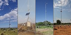
A large number of automatic weather stations has been implemented in the frame of the BIOTA AFRICA project by the Namibian National Botanical Research Institute (NBRI) and the Group "Biodiversity, Evolution and Ecology" (BEE) of the University of Hamburg. The website offers hourly updates of data and graphs of a large number of weather parameters.

|
Metadata database
Metadata introduction
Geodata catalogue BIOTA-E02
 Download PDF document Download PDF document
 Last update: 2010-01-11 Done by: C.Weist
 Copy dataset as template Copy dataset as template
| Dataset metadata |
| Description | The collection of geo-spatial datasets covers different topics and scale levels from Africa to observation plots. Every dataset comes with a meta
information file and a quicklook image. Downloading the geo-spatial data
requires a password given to BIOTA-East project partners. By the end of
2009 already more than 220 datasets were included in the geodata catalogue. The BIOTA East Africa geodata service also provides ready-to-use-maps and WebGIS applications and is available at:
http://www.biota-africa.org/East_GISWeb1_ba.php. |
| Purpose |
Access to geodatasets of interest for BIOTA East Africa project partners; an
offline version is available within Kenya and Uganda. |
| Main theme(s) |
Vegetation and land use / cover, landscape, orography, hydrography, climate, geology and soils, aerial and satellite imagery, topographic maps, (administrative) boundaries, infrastructure, population, observation plots |
| Subtheme(s) |
|
| Biome(s) |
forest landscapes |
| Country(ies) |
Kenya, Uganda |
| Administration unit(s) |
|
| Locality(ies) |
Kakamega-Nandi forests, Budongo Forest, Mabira Forest, Kenya, Uganda |
| BIOTA Observatory(ies) |
BIOTA-East BDOs within listed forests (see localities) |
| Period(s) |
1907-2009 |
| Sampling method(s) |
|
| Responsible person(s) |
C.Weist, G.Schaab |
| Regional networks(s) |
BIOTA East Africa |
| Related subprojects / workpackages / topics |
E02: GIS and remote sensing in support of biodiversity management at the landscape scale for rainforests in Eastern Africa |
| Copyright holder |
see metadata description sheets within geodata catalogue |
| Restrictions of dissemination |
see metadata description sheets within geodata catalogue |
| Start time of protection |
see metadata description sheets within geodata catalogue |
| Duration of protection |
see metadata description sheets within geodata catalogue |
| Rationale / notes |
|
| Data |
| Format |
shp, img, geotiff |
| File name(s) / size(s) |
|
| Software requirements |
GIS |
| Documentation |
|
| Format |
|
| File name(s) |
|
| Status |
|
| Notes |
all geodatasets and documentation can be found at:
http://www.biota-africa.org/East_GISWeb2_ba.php |
| Related publications |
Walter, M. & G.Schaab (2005): WebGIS zur Unterstützung von Online-Geodatenkatalogen Realisierung für das BIOTA-Ostafrika-Projekt. Kartographische Nachrichten. Fachzeitschrift für Geoinformation und Visualisierung, 1/2005, 17-25. |
|
|
 Go to the WeatherNet