 


Weather data
A large number of automatic weather stations has been implemented in the frame of the BIOTA AFRICA project by the Namibian National Botanical Research Institute (NBRI) and the Group "Biodiversity, Evolution and Ecology" (BEE) of the University of Hamburg. The website offers hourly updates of data and graphs of a large number of weather parameters.

|
< back
Workpackages of Subproject E02
Workpackage WP02.1
Expansion of the existing GIS and capacity building in Kenya
Short description:
- Expansion of the existing GIS: collecting datasets for the new study sites in Uganda, data preparation for the BIOTA-East-GIS online geodata catalogue, development of a biodiversity research support tool.
- Capacity building: supervision of a PhD candidate in Kenya and two M.Sc. students in Germany,seminars for the Kenyan counterparts, interdisciplinary cooperation with the other subprojects.
Workpackage WP02.2
Continuation of remote sensing analyses and environmental education
Short description:
- Elaborating the remote sensing analyses: analysis of historical aerial photography, land use/cover change time series for the additional study sites based on Landsat imagery, their analyses regarding biodiversity-relevant indicators, improvement of the derivation of biophysical properties from MODIS-data based on the development of a LAI algorithm especially for East Africa.
- Supporting environmental education: visualisation of land use/cover change time series for the local communities.
Workpackage WP02.3
Interdisciplinary cooperation with other subprojects of BIOTA-East
Short description:
- Cooperating with other BIOTA-East subprojects concerning specific research questions: various geo-data and field observations are combined via spatially explicit GIS- and/or remote sensing-based modelling approaches at the landscape scale.
|
|
|
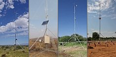
 Go to the WeatherNet