 


Weather data
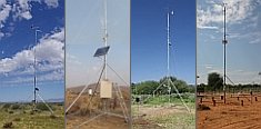
A large number of automatic weather stations has been implemented in the frame of the BIOTA AFRICA project by the Namibian National Botanical Research Institute (NBRI) and the Group "Biodiversity, Evolution and Ecology" (BEE) of the University of Hamburg. The website offers hourly updates of data and graphs of a large number of weather parameters.

|
< back
Subproject E03
Dr. Helmut Dalitz, Bielefeld University, Faculty of Biology, Dept. of Ecology,
Universitätsstr.25, 33615 Bielefeld, Germany
Regeneration of tropical-montane tree species: dynamics of feedback processes
in time and space and their modelling
Summary
In this section we want to examine the spatial distribution of tree species
along a gradient of fragmentation. Light availability under the canopy, input
of nutrients from the atmosphere and input of nutrients on the forest floor
will be investigated. The idea is that variable conditions of water and nutrient
supply as well as variations in light conditions are responsible for the regeneration
of tree species. Another aspect is the preparation a plant inventory of the
Kakamega forest in cooperation with other groups, presenning all plants in a
database with digital pictures. The self-generated software product "Visual
Plants" will be used. It has already been used in similar projects in Costa
Rica and Ecuador.
Methods
Spatial distribution of plants: all trees with more than 5 cm BH-diameter
will be recorder on 400 m2 plots with reference to their spatial arangement.
Crown architecture will be investigated with hemispherical photographs (HemiView,
DeltaT), and light conditions will be monitored through measurements of photosynthetic
active radiation (SunScan-system, DeltaT).
Nutrient input: Bulk precipitation of rain and of canopy throughfall
will be collected and analysed for all relevant cations. Results are to be related
to canopy structure to find possible correlations between nutrient fluxes and
forest structure. The collections of precipitation and canopy throughfall should
be carried out for two years.
Soil chemistry: Water extractable cations and total content of soil horizons
will be investigated with referecne to cation content and temporal variation
at different sites within the plots.
Inventory of plants: Flatbed scans, digitized scans, and digitzed herbarium
specimen will be collected in the software "Visual Plants". This will allow
the presentation of plants pictures on a computer monitor and searching and
identifying plants with only a few known vegetative characters.
|
|
 Go to the WeatherNet