|
|||||||||||||


Weather data
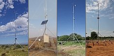
A large number of automatic weather stations has been implemented in the frame of the BIOTA AFRICA project by the Namibian National Botanical Research Institute (NBRI) and the Group "Biodiversity, Evolution and Ecology" (BEE) of the University of Hamburg. The website offers hourly updates of data and graphs of a large number of weather parameters.
|
< back Subproject W01
Subproject Coordination: Dr. Michael Schmidt, DLR, Deutsches Zentrum fuer Luft- und Raumfahrt e.V.,
DFD, Deutsches Fernerkundungsdatenzentrum, Postfach 1116, 82230 Weßling.
|
 Go to the WeatherNet
|
This Biota Africa Subproject W01 is aiming at remote sensing and GIS based monitoring of vegetation, land cover and biodiversity dynamics at multiple scales along the BIOTA West transect. In continuation of the assessment and monitoring of vegetation spatial patterns at the local scale in Phase I, the focus in the Second Phase will be on the monitoring of vegetation dynamics and resulting changes in biodiversity on multiple scales. On the one hand studies of local vegetation dynamics, comparative to the Comoé National Park study will be performed at the Tai National park. On the other hand, vegetation changes shall be analysed with regard to their dependency on climate and land use on the regional to continental scale. Within the research plan, biomass as a limiting factor of livestock grazing capacity, as well as other biophysical vegetation parameters will be assessed by combining field measurements of partner subprojects and remote sensing indication at selected biomes along the transect. Spatial diversity of landscape structure and vegetation spatial patterns as two aspects of structural diversity shall furthermore be addressed. In support of all spatial analyses, the BIOTA West GIS will be maintained and new satellite, spatial and climate data will be integrated. In order to understand natural processes of changes in vegetation and biodiversity on larger scales, the dependencies between vegetation dynamics, climatic variability and human land use will be analysed on a regional scale, covering Western Africa (Ivory Coast to Northern Benin and Burkina Faso). Future climatic scenarios, developed together with W02 and "the GLOWA-Volta-Project", can help to evaluate future changes in growing, germination and seeding circumstances for vegetation and simulate changes in species diversity. Following the analysis of dependencies between vegetation and climate patterns, the role of human induced land surface patterns and changes with special emphasis on land degradation shall be examined. Using time-series of remote sensing data, analyses will be run on how human land use processes affect vegetation and biodiversity development over time by analysing where, when and how land transformation takes place. Finally, the implementation of biodiversity management tools will be supported by a review of remote sensing based products and evaluation of their suitability for use as indicators in a sustainable biodiversity monitoring and management concept. Capacity building in the fields of remote sensing, geostatistics and statistical modelling will be continued for African and German partners. Workpackages: WP1 WP2 WP3 WP4 |

 |