|
|||||||||||||


Weather data
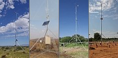
A large number of automatic weather stations has been implemented in the frame of the BIOTA AFRICA project by the Namibian National Botanical Research Institute (NBRI) and the Group "Biodiversity, Evolution and Ecology" (BEE) of the University of Hamburg. The website offers hourly updates of data and graphs of a large number of weather parameters.
|
< back Subproject W03
Head of the subproject: Prof. Dr. Wilhelm Barthlott, Nees Institute for Biodiversity of Plants, University of Bonn, Meckenheimer Allee 170, 53115 Bonn, Germany
|
 Go to the WeatherNet
|
A central target of the Convention on Biological Diversity is "to achieve by 2010 a significant reduction of the current rate of biodiversity loss". Understanding large scale patterns of biodiversity is fundamental for its conservation and sustainable use. Since 1995, the Nees Institute for Biodiversity of Plants is concerned with the mapping of large scale patterns of biodiversity. Within the framework of BIOTA, Africa is investigated as a model continent to understand principal processes shaping global patterns of biodiversity. Our main focus is the mapping and analysis of the patterns of phytodiversity and its dependence on geodiversity. Incorporating socioeconomic parameters, large-scale strategies for the conservation and sustainable use of biodiversity are evaluated. Results of the pilot phase The database is used for the mapping and analysis of the African biodiversity. In this context, under-sampled areas and under-represented taxa were identified. The efficiency of the current sub-Saharan network of protected areas to cover the diversity of the African Flora was tested. Integrating socioeconomic data such as human population density and land cover, hotspots of high diversity and high potential threat due to human activities had been identified, as well as areas of comparatively intact high biodiversity (high biodiversity wilderness areas). Data are partly published via an Internet-connected database . Several results have been published or are submitted (see publications). Aims of the main phase The results can be used to assess the potentials for a sustainable conservation of biodiversity in a changing environment. Both, anthropogenic development and climate change are considered. The profound analysis of biodiversity-related processes for the model continent Africa contributes to a better understanding of biodiversity on the global scale as well. These insights are used for improved investigations on global biodiversity. Workpackages: WP1 WP2 WP4 WP5 |


 |