 


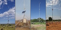
Weather data
A large number of automatic weather stations has been implemented in the frame of the BIOTA AFRICA project by the Namibian National Botanical Research Institute (NBRI) and the Group "Biodiversity, Evolution and Ecology" (BEE) of the University of Hamburg. The website offers hourly updates of data and graphs of a large number of weather parameters.

|
|
BIOTA East Africa - GIS
Geodata Service |
Final update August 2010: - now more than 500 geodatasets included
- 55 ready-to-use-maps
 |
Geo-Spatial Data
This link brings you to a growing pool of geospatial data of use for BIOTA East Africa. For every dataset you will find meta information (in form of a PDF file), a quicklook image as well as a download button. To download the data via ftp a password is required (given only to BIOTA-East project partners). The meta information helps to judge the usefulness of data and provides information on data format, citation, use constraints, etc. The split into hierarchical levels serves as a first indication of suitability, because the data shows a strong increase in detail from the level 'Africa' down to the level 'observation plots'.
|
 |
Ready-to-Use Maps
In certain cases downloading data and their subsequent handling in a GIS might be too much effort. Therefore, we provide here ready-to-use maps (i.e. already formatted maps) for presentations, etc.
|
 |
WebGIS
The WebGIS applications serve the purpose both of a browsing and viewing tool supporting users looking for suitable data, and of a presentation tool putting additional information (e.g. photographs) into a spatial context.
|
| Contact information |
 Karlsruhe University of Applied Sciences Karlsruhe University of Applied Sciences
Faculty of Geomatics / Institute of Applied Research
Moltkestr. 30
D-76133 Karlsruhe, Germany
|
|
Prof. Dr. Gertrud Schaab
(E02 project head and coordinator)
 gertrud.schaab@hs-karlsruhe.de gertrud.schaab@hs-karlsruhe.de
phone: +49 (0)721/925-2923
fax: +49 (0)721/925-2927
|
Dipl.-Geogr. Cornelia Weist
(E02, in charge of the geodata catalogue)
cornelia.weist@hs-karlsruhe.de
phone: +49 (0)721 925-1776
fax: +49 (0)721/925-2361
|
Acknowledgements
Thanks to the many institutions in Kenya and Uganda having made GIS data and map information available, to those BIOTA-East subprojects having provided additional datasets, and to the students from Hs Karlsruhe or at DLR/Uni Würzburg having given a hand in preparing the geodatasets. Until the end of phase 2 the geodata service was maintained at DLR Oberpfaffenhofen.
|
|
 Go to the WeatherNet