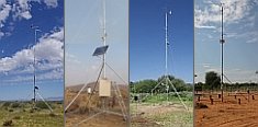 


Weather data
A large number of automatic weather stations has been implemented in the frame of the BIOTA AFRICA project by the Namibian National Botanical Research Institute (NBRI) and the Group "Biodiversity, Evolution and Ecology" (BEE) of the University of Hamburg. The website offers hourly updates of data and graphs of a large number of weather parameters.

|
< back
Subproject S06
Prof. Dr. Norbert Juergens, Botanical Institute and Botanical Garden, University of Hamburg, Ohnhorststrasse 18, 22609 Hamburg, Germany
Ben Strohbach, National Botanical Research Institute, Private Bag 13184, Windhoek, Namibia
Changes in botanical biodiversity as related to changes in land use practices and climate: Standardised monitoring and transect analysis.
|
The botanical subproject is strongly linked to many other subprojects, because on one hand the vegetation is controlled by abiotic and biotic environmental factors and land use, on the other hand vegetation is forming the food base for many consumers, the structural basis for life of many organisms and also the central resource for pastoral land use. Vegetation also strongly controls important processes such as erosion and fire.
- A very strong focus of the subproject is laid on the documentation, classification and mapping of the vegetation along the transect band. Depending on the practical progress, the mapped transect band will be about 30 km wide or wider for the whole length of the transect. This activity will be carried out in very close cooperation with subproject S01 (Remote sensing and GIS). Due to modern evaluation and validation techniques we expect a substantial progress and contribution to the production of a vegetation map of Namibia in particular. At the same time, this map will allow the analysis of shifts in the vegetation over the past two to three decades due to multitemporal satellite information and change detection techniques (S01). The information created from vegetation mapping shall be extrapolated by using floristic biogeographical information and GIS carried information on geodiversity (climate, topography, geology, soils). Depending on scale and the information basis this could allow the ecological explanation of phytogeographical patterns and predictive models on phytogeographic distribution. In this context, the detailed analysis of the expansion dynamics of neophytes and of problematic increasers due to high land use intensity (e.g. bush encroachment) and the movements of migrators might be successfully predicted based on GIS modelling, in the latter case linked to methods of molecular phylogenetic methods (ITS, AFLP).
- The second focus is placed on the floristic component of the Biodiversity Observatories. The detailed annual documentation of species composition and structure on the many subunits of the Observatories will be a major part of the working load of this project. However, this information is of high importance for all other subprojects. In addition, it will be linked to detailed multitemporal analysis via satellite and will allow extrapolation of remote sensing data. The dynamics on the Biodiversity Observatories will later be evaluated for the detection of functional interactions between the different organism groups and the environment. Land use effects will be interpreted by comparison of two Observatories placed in different land use types. A closely related thematic part shall be the establishment of a data pool on functional aspects of the vegetation. Besides characters of vegetative growth, the features of dissemination systems shall be analysed. This part shall be broadened during the main phase of the project.
- In addition, the effects of the land use system will also be analysed outside each Observatory: The specific analysis of the vegetation changes along impact gradients (e.g. around waterholes etc.) will give additional information on the processes, how land use is changing biodiversity.
Practically, the main field work will be linked to the ground survey for the vegetation map and the annual documentation of the Biodiversity Observatories.
South African Partner: Dr. M. Timm Hoffman, National Botanical Institute, Private Bag X7, Claremont 7735.
|
|
|


 Go to the WeatherNet