|
|||||||||||||
 |


Weather data

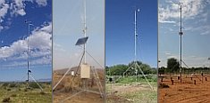
A large number of automatic weather stations has been implemented in the frame of the BIOTA AFRICA project by the Namibian National Botanical Research Institute (NBRI) and the Group "Biodiversity, Evolution and Ecology" (BEE) of the University of Hamburg. The website offers hourly updates of data and graphs of a large number of weather parameters.

|
The Project: BIOTA East Africa Towards a sustainable use of East African rain forest systems: Analysis of biodiversity function and socio-economic drivers along gradients of degradation BIOTA East Africa links a set of thematically strictly co-ordinated analyses of biodiversity changes in the East African highland rain forests. Investigations take place along a degradation/disturbance gradient and include various types of habitats - from moderately disturbed primary forest to secondary forests and completely degraded areas. During the first phase, significant interfaces at different hierarchical levels of the trophic network of rain forests and their replacement communities were critically selected. A GIS-based information system was established to process current remote sensing data and historical information on environmental changes for the study area. Research is aimed at a better understanding of the complex consequences of changes of biodiversity on different hierarchical levels resulting from exploitation and fragmentation. The first phase of the project focussed mainly on the collection of baseline data, the development of rapid assessment methods and capacity building. The following phases are extended to the over-all aim "sustainable use of biodiversity", meaning the long-term sustainability of rain forest systems in East Africa. The approach aims at warranting a maximum maintenance of biodiversity and its function as well as promoting the compatible use of biological diversity with profit for the local population. Major aims are defined as follows:
Kakamega Forest in western Kenya is the main study site. Its habitat mosaic is perfectly suited to investigate the aspects mentioned above along a gradient of degradation and fragmentation, especially when socio-economic studies are concerned. In addition, Kakamega Forest offers the opportunity to evaluate the effect of different forest management regimes and provides an ideal model case. The only restriction constitutes the lack of undisturbed primary forest. Therefore, a comparable area with undisturbed forest (Budongo Forest, Uganda) is included as a reference site and as a testing area for developed assessment methods. |
 Go to the WeatherNet