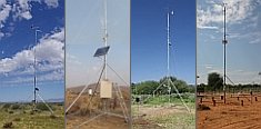
Weather data
A large number of automatic weather stations has been implemented in the frame of the BIOTA AFRICA project by the Namibian National Botanical Research Institute (NBRI) and the Group "Biodiversity, Evolution and Ecology" (BEE) of the University of Hamburg. The website offers hourly updates of data and graphs of a large number of weather parameters.
|
BIOTA Southern Africa - DS&T Project 9
Main |
DS&T 09 |
Title |
Use of BIOTA observatories for validation of MODIS data products -and to provide training and outreach in the use of MODIS imagery |
Project leader(s) |
Dr Richard Knight Biodiversity and Conservation Biology Dept, University of the Western Cape, Private Bag X17, Bellville 7535 South Africa
|
Project description |
This project follows up on two previous projects which have examined long term vegetation responses within each of the Succulent Karoo regions (identified by the Succulent Karoo Ecosystem Project (SKEP) using NOAA data supplied by ARC-Institute of Soil Climate and Water undertaken at UCT and SPOT VGT undertaken at UWC as part of the MAPOSDA project.
MODIS data is downloadable from the Internet, however, since this project will be done in collaboration with German Aerospace Research Centre, German Remote Sensing Data Centre it is likely that it will be sourced through this organization. " |
SADC and International Links |
Since the BIOTA transect includes both South Africa and Namibia these two SADC nations have direct benefit. The study should identify the full potential of using MODIS in other arid and semi-arid regions within SADC such as Botswana. The project, while being undertaken within South Africa (University of the Western Cape), will be guided by Dr Michael Schmidt of German Aerospace Research Centre, German Remote Sensing Data Centre, DLR - Oberphaffenhofen (who has several years of experience in using MODIS data) This will ensure a skills transference from Germany to Southern Africa in a field identified by the Department of Science and Technology as requiring investment within its National Learnership Programmes (Ecological Informatics). Once the potential and realized use and training in MODIS data analysis have been fully evaluated in this project similar initiatives to the BIOTA/LTER could be identified in other SADC nations such as Zimbabwe. This project could also provide useful inputs into the National Research Foundation’s South African Environmental Observatory Network (SAEON) which is planning to have a node in an arid ecosystem and most likely within the Succulent Karoo. It is important to recognize that all remote-sensing applications need to include well-designed validation procedures which include test sites with continuous on the ground data collection that is guided by an active research programme.
Links between the use of MODIS and LTER network have been established through the need for validation between ground data and remotely collected data. Such links have been described in the background section of this document. NASA Global Land Cover Test Sites for MODIS product already include LTER sites. This ensures that opportunities for integrating the results of this project exist with current LTER sites (e.g. the Gobabeb in Namibia) and future ones.
NASA, the operators of Terra Satellite on which MODIS is installed, has field sites for validation through a project called “BigFoot” and these are also EOS Land Validation Core Sites and are part of the FLUXNET program. The sites have active science programs concentrating on [CO2], water vapour, and energy exchange using flux tower measurements. The "footprint" over which gas flux data are collected are similar in size to 1 km2 BIOTA observatories." |
|
|