

Weather data
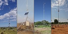
A large number of automatic weather stations has been implemented in the frame of the BIOTA AFRICA project by the Namibian National Botanical Research Institute (NBRI) and the Group "Biodiversity, Evolution and Ecology" (BEE) of the University of Hamburg. The website offers hourly updates of data and graphs of a large number of weather parameters.

|
 BIOTA East Africa - Cross-cutting themes
| CCT - Theme 3 |
Understanding human use, value and impact in space and time |
| CCT Description |
The current state of the agricultural land surrounding the forest will be documented using high-resolution QuickBird satellite imagery. The social and economic needs of the local population will be described to understand the causes of non-sustainable forest use. Improvements for livelihoods around the forest, tools for appropriate land use planning in a participatory way and mechanisms for fair sharing of the resulting benefits will be recommended.
This requires a study of all relevant socio-economic needs of local populations as well at political priorities at regional, national and international levels. There is a great need of mainstreaming economic valuation of forest resources as a tool for decision making in conservation strategies. We will work out models for socio-economical scenarios to evaluate regeneration potential and landscape planning of the agricultural matrix. |
| E02 - GIS and Remote Sensing in Support of Biodiversity Management at the Landscape Scale for Rainforests in Eastern Africa |
| Details |
WP2 |
Spatial extrapolation of BIOTA-East findings on biodiversity and ecosystem function predominantly over Kakamega Forest, plus interdisciplinary analyses considering spatial information |
| Details |
WP3 |
Identifying structural parameters and modelling socio-economic scenarios for the farmland surrounding Kakamega Forest as well as deriving a detailed up-to-date vegetation map for Kaka-mega Forest as a contribution to forest management |
| Details |
WP4 |
Applying spatial information in participatory forest management and landuse planning for Kakamega Forest and surroundings |
| E04 - Flora and vegetation of rainforests in East Africa - conservation and sustainable use |
| Details |
WP1 |
GIS-based vegetation mapping of Kakamega and Budongo Forest - Monitoring and assessment of biodiversity |
| Details |
WP2 |
Distribution and abundance of plant species originating from Kakamega Forest in farms and agricultural landscape elements |
| Details |
WP3 |
Medicinal plants of Kakamega and Budongo Forest |
| Details |
WP4 |
Ex-situ conservation of forest plants in Maseno Botanical Garden |
| E10 - Towards conservation and sustainable use of pollinators |
| Details |
WP1 |
Measures of pollinator conservation and long-term monitoring of bees |
| Details |
WP2 |
Effects of landscape structure and habitat fragmentation on plant-pollinator interactions |
| Details |
WP4 |
The potential of stingless bees and solitary bees as manageable crop pollinators |
| E11 - Human impact on avian diversity, seed dispersal and regeneration processes of East African rainforests: management tools and recommendations |
| Details |
WP1 |
Ficus-diversity as indicator for biodiversity and ecosystem functioning at different spatial scales |
| Details |
WP2 |
Management for high genetic diversity in Prunus africana: seed dispersers vs. pollinators |
| Details |
WP3 |
Multi-disciplinary analysis of data on biodiversity and ecosystem functions |
| Details |
WP4 |
Tropical farmland linking socio-economy, land use and bird diversity |
| Details |
WP5 |
Conservation education and outreach to Kenyan partners |
| E13 - Conservation and Management of Biodiversity for Rural Livelihoods: Developing Sustainable Strategies for Reconciling Stakeholders' Interests in Kakamega Forest |
| Details |
WP2 |
Participatory implementation of experimental extraction and performance payment schemes for sustainable use of forest products |
| Details |
WP4 |
Model-based scenario analysis of agricultural options to increase on-farm biodiversity |
| E14c - Sustainable Use and Management of Biodiversity for Rural Livelihoods: Economic Development in a Peripheral Region |
| Details |
WP1 |
Defining Extrapolation Domains for Agricultural Technology Options to Enhance Biodiversity in Space and Time |
| E16 - Ant and termite communities along a habitat degradation gradient: patterns and consequences for ecosystem function |
| Details |
WP2 |
Diversity and abundance of ants and termites along a habitat degradation gradient |
| Details |
WP3 |
Trophic ecology of ants and termites |
| Details |
WP4 |
Ant predation and herbivore-control: from rainforest to intensively used farmland |
| Details |
WP5 |
Use of farmland habitat, temperature tolerance and the survival of ant species in forest fragments |
| Details |
WP6 |
Effects of termite diversity on decomposition rates |
|
|


 Go to the WeatherNet
 BIOTA East Africa - Cross-cutting themes